skip to main |
skip to sidebar
 Since my first blog postings about Dalway's Bawn in June and July 2010, a lot more information has come to light on this 17th century cattle-fort, and the people associated with it in the 19th century - for in 1860 it was still playing an important role in the cattle trade between east Antrim and Scotland.
 A view of the bawn from the air is interesting because it shows a third (unroofed) corner turret at the back left-hand corner of the bawn. Originally there were four turrets, one in each corner of the bawn, but the interior space is now a mass of agricultural buildings. In 1858 the bawn was surveyed, and it was recorded that the front turrets had been converted into living accommodation as early as 1632. It was also noted that "in its original state it was capable of affording shelter for 200 head of cattle".
 The bawn is in the townland of Bellahill (or Ballyhill), and was occupied in 1860 by Marriott Dalway. On the map of Bellahill I have marked the location of four tenants of Marriott Dalway on his 'home' townland (click on map to enlarge). These four families each have their own stories that help us understand the bigger picture.
First of these is the original homestead of the parents of Andrew Jackson, 7th President of the United States. This (and not their temporary home in Boneybefore where the Andrew Jackson museum is), was the real 'ancestral homestead', and other members of the Jackson family farmed in this area right up to recent times. The ruins of the original house still stand along an overgrown trackway known as "Bullock's Walk" that accessed directly onto the old cattle drove road near Dalway's Bawn.The next Bellahill farm is that of Alexander Harte. In 1860 Alexander Hart (as the family now spell the name) also had farms leased from Marriott Dalway in the North East Division of Carrickfergus, and in the nearby townland of Crossmary. These Harts appear to be the same family that came to Ulster with John Dalway in the late 16th Century (see earlier postings). The connection with Boneybefore is their surviving farm at 'Newseat' up Hart's Loanen from Boneybefore. In another earlier posting ('An uncanny gathering at Bellahill farm, near Dalway's Bawn, in 1953') there is a photo and explanation of the Hart family connection that I had when at Primary School in Eden, and of couse, Hart's Loanen from Boneybefore to the Commons was our gateway to that world.
James Esler of Bellahill was a cattle-hand at Dalway's Bawn in 1860, and his small cottage was on Alexander Hart's farm. His son James Esler (junior) lived a few fields away, in the townland of Dobbsland, and was a 'byresman'. This family was distantly related to me on my mother's side of the family, and all of the Eslers in Antrim at that time were involved with the cattle drove trade to Scotland. I still want to tease out a few things relating to these Eslers in future blogs: a) The Eslers of Islandmagee were a critical link in the final stretch of the cattle drove trail from Ballynure, past Dalway's Bawn, to Portmuck and thence to Scotland. b) The younger James Esler's marriage about 1855 to a Mary Drummond resulted in a fascinating legacy. James and Mary are both buried in Carrickfergus's Roman Catholic Graveyard, so I also want to explore this unexpected thread along with other aspects of the 'Old Irish Catholic dimension' of the Commons and Carrickfergus.
Finally, the farm of Alexander Hoey (later also Hay, Hoy and Hoye) in Bellahill in 1860 was right on the cattle drove trail coming down from the Commons, past the 'resting slap' and on down to Dalway's Bawn. (A 'slap' is an Ulster-Scots word for "a gap in a hedge or dyke allowing the passage of cattle"). This family would not have meant anything to me had I not recently received a fascinating family history from a member of this family in Canada with a detailed account of this particular farm - including this fascinating item:
"There is a tradition among the Hoys in County Antrim that their ancestor came from Scotland as groom in charge of John Dalway's horses, sometime between 1578 and 1606. As a groom, most of his duties were at the castle and bawn. But in time he leased from Dalway a farm about a half mile northeast of the castle overlooking the Muttonburn valley. This farm, or part of it, now belongs to his descendant Isaac Hoy, and the present Hoy home here was probably built by the original Scotch settler."
These four families living in Bellahill give us just a glimpse of the depth of history behind the thing that links them all - Dalway's Bawn.
 Our history in Boneybefore was folk history - tales told to us by the likes of Tillie Millar from the door of her thatched cottage.
"This was once the main horse and coach road to Larne", she told us. "Along here dandered Andrew Jackson's mother, wi' the future President in her wame (womb); and Jonathan Swift, the man that writ Gulliver's Travels, spittin' on the Presbyterians as he passed; and General Thurot wi' his French soldiers marching on Carrick".
"How did Boney get its name?" we asked.
"This is where the French soldiers landed", Tillie said, "and General Thurot told Napoleon that they were at a bonny wee place before Carrick".
That last story made us laugh, for even in those days we knew the French didn't speak Ulster-Scots. But, a large farm above Boneybefore was given the polite name of 'Fair Prospect' and the older spelling is sometimes "Bonnybefore" as it is on the map below. 'Boney' is simply how we pronounced the Scots word 'bonny' in Ulster, and the best-known version of that is in the local song "The boney wee lass" (which has nothing to do with the pretty young girl's frame!)
We never took such folk history very seriously back then, but as I went on myself to travel the long road from Boneybefore to the bigger world, I discovered not only the truth of most of those tales, but that it was my school-book history which was often untrustworthy. In 1760 a Francois Thurot did land 600 French troops 'near Kilroot' and captured Carrickfergus after the 'Battle of Carrickfergus' in the streets of the town. He held it for 5 days and then fled back to France by sea.
On reflection, the most impressive of all Tillie Millar's gems of Boneybefore history was her insistence that the dust-track running through our village was once a main coach road, (something that seemed unlikely to us as we were sandwiched in a backwater between the railway line along the shore on one side, and the wide, main Larne Road on the other side). But the map evidence tells a different story.
 The 'Carrickfergus and Larne Railway Company' opened the line to Larne about 1845, and it cut across the line of the old coach road just before Boneybefore, removing the original Andrew Jackson homestead in the process. From this point a new 'Larne Road' was constructed by-passing Boneybefore and it took a new course through the 'new' village of Eden. But the old line of the original coach road (a dashed red line on map) could still be traced in laneways and footpaths right to the ancient church site of Kilroot when I was a boy.
Kilroot Church was founded in the 5th century, right back at the time of St Patrick. It has the ruins of a bishop's palace and a surrounding bawn wall with two surviving round corner flankers (but nothing like as grand as those at Dalway's Bawn). The old church ruins are just tiny fragments of stone walls, in the middle of an ancient graveyard. Jonathan Swift was appointed Prebend of Kilroot in 1695, and lived nearby.
I have made mention of Jonathan Swift and his Kilroot house in an earlier post, but two other boyhood associations with this ancient site come to mind. There was a large round stone with a cup shaped hollow in it that held stagnant water, and was believed to be a cure for warts. My old school pal Eric Glynn did try it on a wart he had on his thumb, and it did work! I now know this was a "bullaun" stone (check it out on wikipedia) and these are reckoned to be early Christian in date. It has been removed to a local church, I think, as a baptismal font.
The second association I have with Kilroot is the old graveyard. Only once did we ever hear of a burial in our time there. It was a very cold January, and Tommy Donaldson had died. It was his farmhouse in Boneybefore that is now the "Andrew Jackson Museum". The reason the Donaldsons had burial rights in Kilroot must tell a story of its own, but I presume they were an old family with connections hundreds of years before going back to that parish. Anyway, when Tommy died, there was a fierce snowstorm and the Kilroot graveyard was cut off for over 3 weeks. The delay with Tommy lying in 'cold storage' in Boneybefore was the talk of the place for years, and seemed to emphasize the question we all had - why Kilroot?
The other end of the road from Boneybefore was, of course, the road into Carrick town. This was just over a mile, and the line of the original coach road was mostly the same main road as today from Green Street along the Scotch Quarter into the town. .

Right back in 1680, a drawing of the east side of Carrickfergus shows the line of thatched houses in Scotch Quarter (outside the town walls) leading along the shore towards Boneybefore. This is just as Jonathan Swift must have known it when he rode from Kilroot to Carrickfergus and Belfast.
Of course, the Scotch Quarter has only larger, slated houses today, but between there and Boneybefore the road was known as Green Street (from a local linen bleaching works and bleaching green). The houses here were all still thatched as shown in this photo when I used to walk past them into Carrick as a very young boy.
 The house on the extreme right had a sweetie shop in the front room that was open on a Sunday - a bit of a scandal in those days. In the rain we could shelter under the overhanging thatch, and on our way to Sunday School at Joymount Presbyterian Church in Scotch Quarter, we could sin twice at the same time by spending part of our collection and going into a shop on the Sabbath. We all were clutching a 3d bit (a three pence coin) for our collection, and could buy 2d's worth of penny chews and have one penny left for the collection. I think that is my first real recollection of having a guilty conscience!
What a different history this old coach road from Boneybefore had compared to the old drove road in the Commons. But for me the road from Boneybefore is different in another way. It takes me back with sadness to happy memories, if that makes sense.

My home village of Boneybefore between Carrickfergus and Kilroot is where the President Andrew Jackson Cottage and US Rangers Museum can be found today.
Here is what the official information has to say about this ancestral white-washed cabin:At least 12 US presidents had family connections to Ulster and part of this museum is dedicated to the seventh president, ‘Old Hickory’ Andrew Jackson who was in office from 1829 until 1837.
The Jackson exhibition is housed in a thatched cottage built in the 1750s, similar to the one left in 1765 by Jackson’s parents when they migrated to South Carolina. The main living space and bedrooms of the cottage are set out in the style of the 18th century, while the parlour is dedicated to the Jackson family and the career of their most famous son.
In the War of 1812 Andrew Jackson served as American military commander. He became a national hero after defeating the British forces at the Battle of New Orleans and earned his nickname when supporters described him as tough as Old Hickory wood. Jackson later served two terms as president during which he was able to shape the new Democratic Party.
In the garden is an exhibition dedicated to the US Rangers, who were formed at Carrickfergus in 1942. Based on the British commandoes, the Rangers were stationed a short distance from the cottage. They were a spearhead of the Allied D-Day landings and of the 500 volunteers who first formed the Rangers at Carrickfergus, only 87 were alive by the end of the war. The exhibition includes letters sent by serving Rangers and the equipment that they would have carried with them.
If you read this carefully, it does not claim that this was the actual house in Boneybefore that Andrew Jackson's parents lived in. Most of the dozen or so US 'Presidential Homesteads' that are on the tourist trail in Ulster are just that - but the 'Andrew Jackson Cottage' is just 50 yards or so away from a monument with a blue plaque that states "Reputed site of the ancestral homestead of Andrew Jackson, President of the U.S.A. 1829-1837 " As boys, even in those days before plaques and heritage centers, we all knew that the original 'Jackson' house was knocked down to make way for the railway line from Carrickfergus to Larne about 1860. It was more or less behind where the plaque stands, where you can see the railway track along the shore. A different old farm-house behind where this photo has a window in a coach-house that was taken from the original Jackson house.
Boneybefore still had plenty of thatched houses when I was a boy, but only two survive now, and one of these - the one that is now the Andrew Jackson Center - was Tommy Donaldson's farm. 
Tommy Donaldson's House was no 'cottage' - for that means a landless labourer's house. It was a proper farmhouse that had been in the Donaldson family for 300 years. As it stands today, you can see the tall concrete chimney of Kilroot power station behind, and modern housing where Tommy's byre and other farm out buildings used to be.
Take a look at me in my teens outside the same house when Tommy was still alive.
The white-washed out-building at the end was the byre, where I often watched spell-bound as Tommy milked his cows by hand into a white enamel bucket. Every so often he would aim a teat at us and squirt us like a jet from a water pistol.
The two doors at the far end of the thatched long-house were into a workshop and a stable, for Tommy still used horses, and traveled into Carrick by horse and cart. The US Rangers museum is now housed round the back in what used to be the old cart-sheds.
But when I was in my teens, things were already changing in Boneybefore. Gone were the days when Tommy churned his own butter with a horse-walk round the back (the horse walked round and round in a circle and drove an axle inside a building with a barrel full of milk inside that turned on a cog driven by the horse). When I was still aged in single figures, I remember my mother sending me down to Tommy's with an empty jug for a pint of buttermilk to bake soda farls with. Tommy just took the jug into his kitchen where he had a large barrel, dipped the jug in to fill it, and handed it back - waving me away without a word when I offered him a coin to pay. He was a kindly soul, a man of few words, and when I look at the stable door now I remember going there at Halloween to ask for the lend of ropes to bring in cut-down hedgerow branches for the bonfire. No other adult that wasn't a relative would have been as accommodating.  This photo goes back to those days, and here we were, messing about in the street. Tommy Donaldson's house (the 'Andrew Jackson Cottage') is the one in the background, and you can see the byre and store beyond.
The gable in the middle was that of another thatched house belonging to 'oul ma Hagan'. It burnt down in about 1959.
To the left lived Nellie Donaldson, and her hen-house can just be seen on the extreme right.

An even earlier shot looking the other way has Nellie Donaldson's hen-house in the center. Tommy Donaldson's (now the museum) is extreme left, casting its shadow. Oul Ma Hagan's thatched house is on the right, and the other thatched house beyond was Tillie Millar's.
Tillie Millar was another kindly soul who used to come out when we were playing to educate us about the history of Boneybefore.
She told us about the Andrew Jackson's parents, where they had lived in Boneybefore, how they had just moved into a 'wee two-room hoose' from up near Dalway's Bawn, just to get ready for the trip to America. The Jackson's were not really 'Boney folk', she said, and the President was born on the boat to America, but Mrs Jackson smuggled him ashore under her dress. We never questioned the logic of this, as he had to be born in America if he was going to be President.
 Arthur Dobbs of Castle Dobbs, Kilroot, is seen in this portrait as holding a map of North Carolina. He was appointed 'Royal' Governor of North Carolina in 1753, one year after he finished rebuilding Castle Dobbs at home in Kilroot.
His American adventure came to an end in 1795 at another 'Castle Dobbs', his new home at Cape Fear, Brunswick, North Carolina. He died just as he was preparing to return home to Carrickfergus at the age of 75.
He had been the most prominent organiser of Scotch-Irish migration to pre-revolutionary America after he purchased a part interest in 400,000 acres of land in North Carolina in 1745 from the McCulloch estate there. Then, along with McCulloch, Arthur Dobbs was granted another 60,000 acres in New Hanover County.
The first tenants that Dobbs brought over from Ireland sailed in 1751. He described them in a letter as, "my tenants and their neighbours and friends", for they were from Kilroot, Ballycarry and Carrickfergus - and many more were to follow. In 1766 yet another batch of Scotch-Irish settlers from the shadow of Castle Dobbs set sail from Belfast. This contingent bound for North and South Carolina from east Antrim included Andrew and Elizabeth Jackson from Bellahill (Dalway's Bawn). They were the parents of Andrew Jackson, 7th President of the United States. These Jacksons had moved from their family farm beside Dalway's Bawn to Boneybefore near Carrickfergus in preparation for their departure. So, both these 'ancestral homesteads' of 'Old Hickory' will be re-visited at a later date.
 Arthur Dobbs, before taking up his office in North Carolina, had been High Sheriff for County Antrim, a member of the Irish Parliament for Carrickfergus, and Surveyor-General of Ireland. His "Essay on the trade and improvement of Ireland" demonstrated his reputation as an economist, but from 1730 he took an increasing interest in colonial affairs, as well as engaging himself in the attempt to discover the North-West passage. In 1752 Arthur Dobbs finished building his fine Palladian mansion of Castle Dobbs just yards away from the ruins of the old castle built by his great-grandfather (and only a few hundred yards south of Dalway's Bawn).
But by 1747 he had completed his land purchases in North Carolina, and wrote to Mathew Rowan, the Surveyor-General of North Carolina, to ask his advice about,
"which type of artificers or servants I should take with me as most wanted there, such as carpenters, smiths, masons and coopers - and what number would be proper at first or could be accommodated with provisions and necessaries to form a settlement ... upon what terms I should agree with each family, the number of acres, term rent or produce, that I may know how to conduct myself in any bargains I may make."
 The landscaped garden or demesne of Castle Dobbs was laid out by Arthur Dobbs in the early 1700s, and its wooded glen along the Kilroot River was known to the young explorers from Boneybefore as 'Dobbs's Plantin'. It was our Sherwood Forest when we were being Robin Hood, and our woods of Tennessee when we were being Davy Crockett (or Daniel Boone). The townland is 'Dobbsland', which is 'East of Eden' and separated from the old County of Carrickfergus by the Copeland Water.
A short walk up the Tongue Loanen and the road turns sharply to the right towards Dalway's Bawn, in the next townland north called 'Bellahill'. At this turn is where James Esler junior lived. His father, James Esler senior, was in a small house just across the townland boundary, in Bellahill.
The Eslers and the Jacksons of Bellahill bring the connection right back to Dalway's Bawn and the old cattle trail from Ballynure.
 The old cattle drove routes across county Antrim run east-west (across the grain to the north-south direction of most of the main lines of communication). This is because they were heading to the main ports (especially Larne) connecting them to the Scottish drove roads that have been so well documented already on the other side of the 'sheuch'. One Scottish drove road in south-west Scotland is described as 'starting in Portpatrick' where 20,000 cattle a year were being landed from Donaghadee in county Down in 1800. (The parallel story of the county Down drove roads is one I'll leave for another day!)
 For Ulster-Scots, these routes were the main arterial connection between the Scottish mainland and the Ulster-Scots settlers of the 17th century and later. This on-going connection is what shaped the very core of the Ulster-Scots heartland in terms of language, culture and religion. Along these routes are the broadest Ulster-Scots speaking areas, and the most dominantly Presbyterian communities in Ireland.
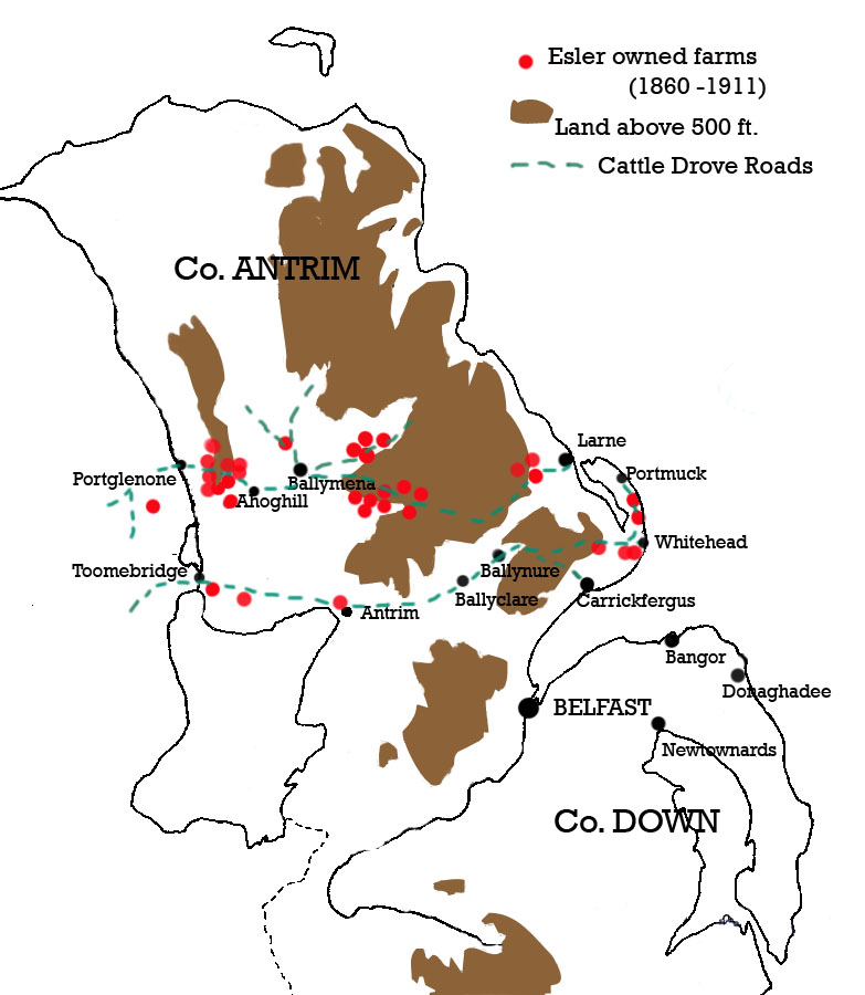
But my efforts at retracing the main drove road from Portglenone to Larne came about as a spin-off from researching the family history of my mother's grandfather - James Esler - whose family came from the cluster of small Esler hill-farms on the 'Long Mountain' between Portglenone and Ahoghill in the 1860s.
Esler is a lowland Scots name (originally German, I understand, meaning 'donkey dealer', or 'hosteler'), and 95% of all Eslers in Ireland were living in County Antrim in the early 19th century. Family tradition has it that three brothers came over from Scotland in the 1600s and settled in three areas - Kilwaughter (on the mountain slopes behind Larne), Eslertown (at the Cross between the Glenwhirry and Braid valleys, east of Ballymena), and Ballynafie (between Portglenone and Ahoghill on the Long Mountain). The map shows these three clusters, and it seems the Eslers' control of the hill pastures was strategically placed at points on upland pasture between market towns where the drovers and their beasts could stop off for the night.
So, that's where I was with my 'historical exploration' when I discovered that two James Eslers (father and son) were also living in 1860 beside Dalway's Bawn, east of Eden in Carrickfergus.
Two things seemed to confirm that this was connected to a cattle trail from Ballynure to Whitehead and Islandmagee. In the first place, both James Esler and his son from Bellahill were 'Agricultural labourers' rather than full farmers, and James Esler Senior was a 'byresman' for Dalway's Bawn itself! (A 'byre' is a cattleshed). Secondly, there were other Esler farms in the immediate vicinity. A 90-acre farm right on the coast at Whitehead was shared in ownership between two Esler brothers in 1860. These brothers were also joint landlords for the newly-erected Coastguard Station and houses in Whitehead. What an opportunity to keep an eye on the Customs and Excise men! Yet another two Esler farms were located in the townland of Balloo, in Islandmagee. These were on the Gobbins Road from Whitehead to Portmuck, which had a small harbour where pigs were exported to Scotland and horses brought in. The Gobbins cliffs between Whitehead and Portmuck had a few hidden coves and 'smugglers caves' - and one of these was on the Esler farm at Balloo! A 'horse cave' at Portmuck was where horses smuggled in were supposed to have been hidden, and I like to think that the Eslers were not only bringing cattle and pigs from Ballynure to send to Scotland, but were bringing horses in the other direction - to Ballynure Fair Hill which was renowned for its annual horse fair.

Going back to the Elizabethan history of this part of the world, Portmuck Castle and Castle Chichester at Whitehead were important outposts of Chichester at Carrickfergus, but they were also linked in terms of strategic defense to Dalway's Bawn.
Castle Chichester was excluded from the Esler farm land which surrounded it at Whitehead, as it was owned by the Chichester family, but the adjacent port was where regular postal packages from Scotland were landed in the 18th century. Of course, as I observed before, 'muc' in Irish is 'pig' - so 'Portmuck' means 'swine port' (nothing to do with the cleanliness of the harbour!)
 The Commons of Carrickfergus appears on the 1832 map (see last post) as a vast, featureless upland moor, devoid of any evidence of human activity apart from the cattle trail across it. But around the edge was a string of stone-built herds' houses which all seemed to look onto the commons just in the same way as a lough-shore fishing community might be strung around a large lough.
It was only when the revelation came that there was a 'necklace' of old houses around the commons did I realise that the only ruined house 'in' the Commons that I remember discovering as a boy was one of these - right on the boundary of the Commons, near Lough Mourne. Back then (50 years ago) it was roofless and overgrown, and when we pushed our way inside through nettles and brambles, I found a glass sitting on a remains of a window sill.
That glass was badly made, with a crooked stem, an air bubble in the base, and an uneven rim. It went with me in later years to student flats and anywhere else I called home as a sort of token of the many local mysteries and childhood wonders that, one day, I would resolve.
I wrote it into a novel, The Man Frae the Ministry, in a different setting altogether (a fictional Ulster-Scots settlement in Canada), where it became the proof of a former visit by Sam and Joel to old Sawney's house:
'His eyes went from the spot where Sawney had been sitting and spitting into the fire, to where the window was above the table - a table that was now a pale anaemic nettle. There was a small glass, half-full of dirt, on the sill of the glass-less window frame. It was the only piece of furniture to be seen. Sam lifted the glass, emptied it, and ran his finger round the inside to clean it out. "Not broken - nice", he said replacing it by its short stem. It had a slight tilt and a bubble flaw in the base.'
I think life is full of little 'coincidences' and events that only have meaning later. As the gospel song says, "Further along, we'll understand why".
Of course there are other antiquities in this 'barren' land of the Commons. Although permanent buildings weren't allowed until about 1870, seasonal huts made of sods and branches called 'booley huts' were numerous and in parts of the commons their circular pattern can still be traced on the ground. 'Booleying' was the summer grazing of cattle on the mountains and often the children and women lived they for the summer months in these temporary shelters, leaving the men to work the arable strips of 'infield' around the lowland hamlets or 'clachans' of stone-built cottages.
During the time when only Freemen of the town of Carrickfergus had grazing rights on the Commons, the booleying may well have been something that was practiced unofficially by remnants of the 'Old Irish' population living to the back of the Commons in places like 'Ardboley' and 'Milky Knowes'. The huts were always near a fresh water supply, and indeed they are found near 'Bryan O'Neill's Well' and down along the sides of the Woodburn river and the Craignabraher Burn. The Craignabraher Burn gets its name from the 'Friar's Rock' in the Commons which was once both a 'Mass Rock' for Irish Catholics and a 'Field Conventicle' site for Scotch Covenanters in the Penal days. In the 1800s, once the Penal Laws and the Test Acts were repealed, a 'Mass House' (Catholic Chapel) was built to the north-west, and a 'Meeting House' for Covenanter Presbyterians was built to the north-east. These Covenanters were known in Ulster as 'Mountain Men', and I often wondered was there a connection with their American kinsmen, the 'Hill-Billys', for 'billie' is the Scots word for 'friend ' or 'comrade'.
Lough Mourne itself was temporarily drained in the 1920s while it was being converted into a reservoir, and pre-historic dug-out boats were found, along with two artificial islands (crannogs) that were used 1000 years ago as defensive Irish homesteads.
A host of Irish place-names in the Commons testify to the survival of the language into more recent times, along with a smattering of Scots and hybrid Irish and Scots place-names as well. But unlike townland names which have often survived because they were written into land-leases, these local names are a real clue to language and culture of the 'commons' folk.
Craignabraher (Irish: Rock of the Friar or Priest)
Slimero (Irish: Red mountain plain)
Toppin (Scots: Cairn or peak of a mountain)
Isle of Glass (Irish and Scots: Green hill in the bog)
Duncrue (Irish: Fort of the cattle payment)
Munney Braddy Moss (Irish and Scots: Stolen peat bog)
Carnwhissock (Irish and Scots: Cairn of the severe blow)
Lignaca (Irish: Hollow of the mist)
 For the final antiquity, we must go down the Cattle trail off the Commons to Dalway's Bawn. Here, East of Eden, an old Irish Harp was found in a bog beside the Bawn in the 1700s . This is the famous 'Dalway Harp', so named because it was kept by the Dalway family for years and is now one of the most treasured possessions of the Irish National Museum in Dublin. Dated to 1621, its image is used by the Irish state as its logo, and the name 'Dalway Harp' has become the generic name for this type of classic Irish harp.
 Up till now, I've only been able to show glimpses of the Cattle trail across the Commons of Carrickfergus as it survived after the Commons was broken up into farms after 1860.
It has taken me weeks to get hold of it, but at last I have a copy of the 1st Ordnance Survey map of the area in 1832. To my delight, it shows the whole townland of 2,730 acres without any farms, fields, fences or buildings. And right across it is an unfenced trackway which I have highlighted in green. It is exactly where it was anticipated.
Another thing that springs out (click on the map to enlarge it and see for yourself), is that the boundary of the Commons has a multitude of small houses lined right along the boundary. Before the 1860 enclosure, permanent dwellings were prohibited, so these were herds' houses, squatters' cabins, or shelters used by drovers and peat diggers.

The same thing is shown on the 1832 map further west, towards the middle of the Commons - small cabins or houses lined along the boundary, and the trail cutting across north of the source of the Woodburn River which flows down into Belfast Lough on the West side of Carrickfergus.
The source of the Woodburn River is marked on this (and later maps) as "BRYAN O'NEILL'S WELL".
 Since my first blog postings about Dalway's Bawn in June and July 2010, a lot more information has come to light on this 17th century cattle-fort, and the people associated with it in the 19th century - for in 1860 it was still playing an important role in the cattle trade between east Antrim and Scotland.
 A view of the bawn from the air is interesting because it shows a third (unroofed) corner turret at the back left-hand corner of the bawn. Originally there were four turrets, one in each corner of the bawn, but the interior space is now a mass of agricultural buildings. In 1858 the bawn was surveyed, and it was recorded that the front turrets had been converted into living accommodation as early as 1632. It was also noted that "in its original state it was capable of affording shelter for 200 head of cattle".