
 The only landing place on the island is on the landward side, and it was here that smuggled horses from Scotland were landed out of sight of any patrolling customs and excise boats. On the Gobbins coast almost opposite is a cave known as 'horse cave' where the smuggled horses were also hidden. The inward horse trade was the counterbalance to the outgoing cattle boats destined for the great drove roads of Scotland.
Looking down on the island from the high ground in the middle of the peninsula, the small harbour of Portmuck can be seen to the left, hidden from the
 isle by a small headland with farm buildings on top.
This scene has hardly changed in 100 years since the old photograph below was taken.

The ruins of Portmuck Castle are only the base walls of a stone tower built in the 1590s (see earlier posts "The Big Picture: Eslers and the 'Scotch' Cattle Drove Roads of mid Antrim", and "Dalways Bawn: The Earl of Essex's Plantation in east Antrim). It sits among and behind the farm buildings on the headland, so that it could overlook both the harbour and the 'sound' of water between the headland and Muck Isle. The large building down at the harbour was the Coastguards Building, which in the 1800s replaced the castle as the customs control center for the control of livestock imports and exports.

This was the end of the cattle trail as far as the old drove road from Ballynure, across the Commons of Carrickfergus and past Dalway's Bawn, but it was the beginning of the horse trail in the opposite direction, for Ballynure's horse fair was one of the biggest in the county.
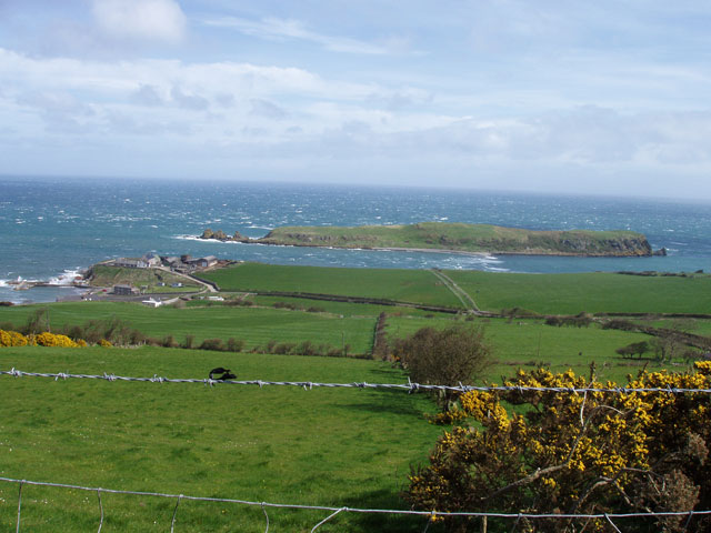
 When I was a boy, the shore opposite Muck Isle could only be accessed by climbing over the limestone rocks at the headland (there is a footpath now).
 From this headland, where the castle ruins are, the shore is a limestone platform of white rocks which contrast completely with the black basalt rocks of the Gobbins cliffs. The castle wall rises straight from this headland on the Isle of Muck side, so that it had a clear view of the 'sound' and the causeway that linked the island. This natural causeway can be waded across at low tide, and of course, livestock could be driven across at this point too.

There is a very interesting account of how (because of the smuggling trade) the locals were unwilling to admit, even to Scots 'plantation' landlords, that there were any horses 'to be had' in the district in the early 1600s. The source is a letter of 1631 from J. Montgomery of Newton (Lord Montgomery of the Ards in County Down) to Archibald Edmonston of Red Hall, Ballycarry. Of course there were plenty of horses about, but the fact that they were all busy working sounds like a typical Ulster-Scots bargaining tool to effect a sale at an extortionate price.
"J. Montgomerie to Archibald Edmonstone of Duntreath. Requesting the loan of some horses.Of course, I should have repeated in this post that the names of Portmuck and of Muck Isle are both derived from the Irish Gaelic word for 'pig' (muc) and the names have nothing to do with the state of cleanliness of the place! But it also shows that the so-called 'cattle trail' was frequented by other livestock as well - particularly horses and swine.
1631, April 21st, Knockfergus [Carrickfergus]. - 'Worshipfull and loving coosen, It hathe so falne out that in my passage from Dunstey I have been forced to land far doun in Iyeland McGhie [Portmuck, Islandmagee] so as I ame forced to employ my freinds for supplie of horses, and in regarde the countrey is upoun the heate of there labour, I must intreate yow for the laine of some three or four garreins [small work horses] for the transporting of myself and company to the Newtoun [Newtownards] ... Signed, Montgomerie
[Reply on same page] Right honourable my, I sent your Lordship thrie garreins and for this present I have non els exept my gray hors that rane ane cours yeisterday, and I dar nott ventur him so schoune efter the race. My Lord, I tak very unkindly that ye suld have gone by this cottage, always I hop your Lordship vill mak ane amends. Thus in quhat I am able I remain ... Signed, Ar. Edmonstoun. "

Beautiful photos. Interesting post, as always.
ReplyDeleteThanks Gorges. I was wondering how I could make a connection with your post on salted fish, as it triggered in my mind the idea that pre-refrigeration, the only way of getting fresh meat from Scotland and Ulster to the Smithfield meat markets of London was on the hoof!
ReplyDeleteIf you check out my profile picture, the rocks in the background are the left-hand end of Muck Isle. A sheer coincidence!
ReplyDeleteOh the photos are beautiful. My mind wanders when I look at these and hear the account from days gone by.I would LOVE to see this place in person...I feel very drawn to it.I can't explain but I look at it and feel connected. I'd love to sit on the hillside and look out at the ocean and smell the salt air.
ReplyDeleteSmugglers, I can believe that. It was a hard life back then. It should have a nicer name.
Thank you Phillip, I appreciate learning this.
Great photos, and a beautiful piece of coastland. Like Crystal Mary, I should like to spend a day wandering there, and rowing over to the island itself. In my teens I rowed a lot, but seldom since then. Would bartering (horses for cattle) been part of this commerce? If no money was involved, it might be a way to circumvent the excise tax.
ReplyDeleteOne of your photos seems to show that, at low tide, perhaps it is possible to walk to the island?
ReplyDeleteGary, yes it is possible, for a short time at what we call a 'spring' (neap) low tide to walk across. (It is a small window of opportunity, but, and wouldn't leave much time for exploring.
ReplyDeleteBartering wasn't usual -but once landed, who could tell that the grazing livestock were smuggled anyway. It was tobacco and spirits that the excise men wanted to uncover - and sometimes did - along the Gobbins!
Crystal Mary,
ReplyDeleteHaving seen all those amazing photos of your Australian landscape and wildlife, it makes me really proud that you should be impressed with my own wee corner of the world. Thanks so much - we should all appreciate more what we have at our own doorsteps, but I do love to hear about other places too. All creation sings the Glory of the Lord.
Yes Phillip, Creation does sing the glory of God. You are so right. I just popped back in...and here are these lovely photos again...
ReplyDeleteWorth the time to look and reflect.
LuckyClub Casino Site - Live Dealer Games
ReplyDeleteLuckyClub Casino Site is an online betting and live casino site offering sports, casino games and poker to Australian players all over the world. Play here! Rating: 5 luckyclub.live · 3 votes
Came across this via Google. My Grandmothers family (MacClelland) owned the "Farm" where the ruins are located from the 1600s to the 1950s. My several times grandfather was part of the United Irish Rebellion and hid in the cave on Muck Island while the English were looking to hang him (he eventually became the local Sherrif!)
ReplyDelete