skip to main |
skip to sidebar
 In this detail of a map prepared for Sir Thomas Smith's Plantation of the Ards in 1572, "Belfurst" (Belfast) is shown at the head of the "baye of Knokfergus" (Carrickfergus Bay, as Belfast Lough was once known). But just north of Knokfergus (west is at the top of this map), on the barely distinguishable peninsula of Islandmagee, is marked "Portmuk" (Portmuck).
Mark Thompson has just posted this illustration on his "Bloggin fae the Burn" blog site (as a follow-up to his recent publication Sir Thomas Smith's Forgotten English Colony of the Ards and North Down in 1572). In earlier postings of my own I talked about the cattle raids of Bryan McPhelim O'Neill on the Commons of Carrickfergus and the Smith colonists in county Down as a prelude to the arrival of John Dalway with the Earl of Essex in 1573.
Of course, John Dalway eventually married into the Clandeboy O'Neill dynasty and obtained massive estates from the O'Neills between Whitehead and Ballynure in east Antrim. This land grant was confirmed by Queen Elizabeth and James I before Dalway's Bawn was built in the early 1600s.
But this map (of 1572) shows "Bryan Ferty" between Belfast and "Glanyboy" (Clandeboy) in the back country between Ballynure and Antrim town. Trouble is, Bryan Fertagh O'Neill, who had been Lord of Clandeboy before Sir Bryan McPhelim O'Neill, was killed in 1548, nearly a generation earlier than the Smith plantation.
Bryan Fachartach (also Ferty, or Fertagh) O'Neill, was great, great grandson of Aodh Buidhe (Hugh Boy) O'Neill, the progenitor of the whole Clandeboy (Clann Aodh Buidhe) O'Neill dynasty in east Ulster in the late 14th century.
However, this is ground I have covered before, so what is new? Well, we know that before John Dalway "established" the cattle trail from the lands behind Carrick to Scotland via Portmuck and Whitehead, it was the O'Neill's who were in control of the cattle-based economy in the hinterland of the medieval English colony of Carrickfergus. The trade from Carrick was with England although in the 1590s Elizabethan tower-houses or castles were also built at Whitehead and Portmuck to defend these "new" trading ports. But this map suggests that Portmuck was operating as a port (and a strategic one at that) at a time when the O'Neills controlled Islandmagee and east Antrim. Was there a cattle trade with Scotland in Bryan O'Neill's day? I think it is possible, and it could mean that our cattle trail is of even greater antiquity than from the days of Dalway's Bawn.
 Postscript: I had just finished this post when Mark Thompson e-mailed me the short message: "Here's another"! This map is what was attached - it must be about the same date as the 1572 one as it has "Smites" castle marked on the Ards peninsula. But here again is "Karregfergus" and "Port Muk" (and perhaps Muck Isle marked as "The Kowe").
Another postscript: I mentioned before that Adrian McKinty's three fantasy novels (The Lighthouse Trilogy) set on Muck Isle at Portmuck involved a fictional American boy, Jamie O'Neill, who inherited the island and a "Laird of Muck" title from the ancient Ui Neill owners of the area. Well for those with local knowledge that think such a connection with the O'Neills is impossible - well, think again!
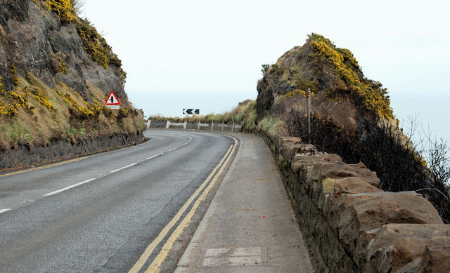
 Whitehead is a quiet sea-side town, just a short hop on the train from Carrickfergus towards Larne. The road 'East of Eden' to Larne goes past the back of the town too, but it is a bit of a push on the bike as the road climbs over the high headland of "Whitehead" at a place called the "Blaa Hole", then down a very steep side road into the town.
 The Blaa Hole (blow-hole) was, as the name suggests, a bit of a wind tunnel. I remember my dad wakening me up to show me his first car that he had brought home the night before. He took me a run to Whitehead and back before school, and, coming through the Blaa Hole, the bonnet flew up and covered the view out the windscreen. So I had good reason to remember the reason behind the name - for the sea was a terrifying 200 feet below when we finally stopped against the stone wall!
 The view looking down on the town from the Blaa Hole shows the promenade, an open-air swimming pool and the small quay at the far end of the bay. This residential town I remember being full of "oldies" (retired senior citizens), and as a place where our parents took us for walks along the shore to Blackhead lighthouse on the far headland.
But as boys we sometimes walked to Whitehead along the railway track, past Jonathan Swift's  "Round House" at Kilroot, and along the coast to the White Harbour, underneath the Blaa Hole. This was a hidden world with a limestone quarry on the landward side of the railway track, and the derelict White Harbour (it was silted up then)on the other. It was built of massive cut white limestone blocks, and was once used to export the limestone. It was such a marvel to us that our walks to Whitehead often never got past this point.The railway tracks separated here, with a single track hugging the coast, and the Whitehead-bound track cutting through the headland into a short tunnel which still emerges immediately into the town. The two tracks converge before reaching the period railway station in Whitehead, surviving much as it was when it was built in 1877.
 Whitehead is the gateway to the peninsula of Islandmagee. It is a Victorian sea-side "railway town", and when the station was opened, it became a tourist haven for day-trippers from Belfast, especially those wanting to visit the Gobbins Cliff Path in Islandmagee by connecting jaunting car, or the nearby Blackhead lighthouse with its similar but less daunting cliff walks.
 This earlier view of Whitehead from the Blaa Hole about 1900 is deceptive. It gives the impression of a long-established settlement, but in fact the oldest buildings visible are the Customs Houses in the middle foreground with the square Watch-tower at the far end. This Customs Station was built just before the railway about 1850. The map of the townland of Whitehead in 1860 tells a very different story as far as the age of the town is concerned.
 Here, in 1860, we see the railway line completed but no station built as yet, and there is no town whatsoever. The entire area of the present town, from the coast to the main Larne road, was a 100-acre farm in the hands of William and David Esler (spelled Essler in the 1860 land valuation). This included the Coastguard Buildings which were leased from this farm and the significance of these Eslers to the running of the Antrim cattle drove trails to Scotland has already been described in an earlier post ("The Big Picture: Eslers and the 'Scotch' Cattle Drove Roads of mid Antrim", August 2010). The fact that they were landlords for the Whitehead Customs buildings at this port at the end of the Dalway's Bawn Cattle Trail is quite staggering! But, as we shall see, the Esler control was even more decisive in Islandmagee proper.
 The two tiny ports of Whitehead and Portmuck that link the end of the east Antrim Cattle Trail with the main Scottish Drove Roads were effectively "twinned" from the 16th century down to the 1850s. Each had an Elizabethan "castle" maintained and garrisoned from Carrickfergus - not for defence, but to control the customs duties due from trade with Scotland. These subsidiary "creeks" as they were called in the 17th century were a constant headache for the main port of Carrickfergus, and so the Customs stations at Portmuck and Whitehead were their direct descendants.
Castle Chichester in Whitehead is the only pre-Victorian building in the town (its shared history with Portmuck Castle is also described in previous posts).
Whitehead was one of two tiny ports marking the end of the east Antrim Cattle trail. The trail splits behind Muldersleigh Hill north of Whitehead, the hill whose coastal headland is the location of Blackhead lighthouse. I have added to a contextual map of Islandmagee and Whitehead not only the route of the end of the Cattle Trail, but also the location of the Islandmagee farms of Patrick and Andrew Esler in 1860 siuated side by side between the Gobbins Road to Portmuck and a small break in the Gobbins cliffs called "Heddle's Port".
The Eslers' farms in Islandmagee were mostly in the townland of Balloo, about midway along the Gobbins coast, and a few hours cattle drove from Portmuck. Unlike the Eslers at Whitehead, they had no interest in the port itself, and maybe had good reason to be just out of immediate sight of the Customs Station there. Smuggling was of course, illegal, but when it involved simply the occasional avoidance of duty payments for horses being landed or cattle being shipped out to Scotland, it was not as rigorously pursued as the illicit trade in spirits and tobacco. A row of thatched cottages at the end of Sally Kane's Loanen on Patrick Esler's farm in Balloo was called "Caleery-town". According to the local historian Dixon Donaldson writing in the 1920s, this name was given because it was a popular rendezvous for the "young bloods" of the neighbourhood. Dixon Donaldson also wrote that there were smugglers caves along the Gobbins. One near Portmuck "... is called the Horse Cave where it is said stolen horses were hidden until transferred to smuggling vessels for transportation." Another cave, long forgotten, was discovered by two boys on the farm of Mr. Esler's "... on the face of the heughs above Heddle's Port. A rope and candles were procured ..." and the boys discovered the remains of barrels and other contraband. (Every time I read this, I think of Tom Sawyer and Huckleberry Finn!)
If, as seems likely, the "Esslers" of Islandmagee, Whitehead and Dalway's Bawn were all related, it is the Islandmagee farm which seems to be the earliest settlement. A local graveyard near Balloo has all the known Esler graves, some going back to the early 1800s and apparently including an "Uncle David" Esler of Whitehead.
These 'East of Eden' Chronicles have stumbled on many connections with famous writers such as Jonathan Swift and Mark Twain. And there are others still to be met with. But just now, for reasons which will soon become obvious, I must bring the modern crime writer Adrian McKinty into the story. He was born and raised in Carrickfergus, only a stone's throw away from Boneybefore, although he has lived for most of his writing career in America and Australia. Adrian McKinty is best known as a writer of crime and mystery novels such as the award-winning "Fifty Grand", or the one I first discovered, "Hidden River".
I was outside a shop in the south of England, impatiently waiting for my wife and browsing through some books for sale. American crime novels are not usually my scene, but the author's name (McKinty) caught my attention: a Les McKinty lived nearby to Boneybefore when I was a boy, and he cycled to work every day to Castle Dobbs where he worked on the Dobbs' estate. His sons were in the Star of Eden Pipe Band, so imagine my surprise when I flicked open the first page and found that the American detective in the story was originally from Carrickfergus! Eagerly reading whatever else of McKinty's books I could get hold of, I found that I actually liked these crime novels anyway. But the bonus was that several of his books have really strong local associations: "Orange Rhymes with Everything" is set in Carrickfergus, and "The Lighthouse Land" in Islandmagee.
 In fact, the main setting of "The Lighthouse Land" is Portmuck, or to be precise Muck Isle. The book is the first of three in the Lighthouse Trilogy of "young adult sci-fantasy novels" - different from the decidedly adult crime novels. A young American boy, Jamie O'Neill, inherits the small isle of Muck through a previously unknown descent from the Elizabethan Clandeboy O'Neills - and travels to take up his new life across the causeway on the island:
"But the island has a secret, locked in the top of its ancient lighthouse ... Discovering the secret will send him on an interstellar mission that could change the course of his life, and the universe, forever."
The story is well worth reading, even as an adult, but I can't resist being parochial in my enthusiasm. The area around Portmuck is described vividly as Jamie makes local friends and travels daily to school in Carrickfergus. So too is Muck Isle, apart from the obvious fact that the real Muck Isle doesn't have a lighthouse.
 That is where Blackhead Lighthouse at Whitehead comes in. Adrian McKinty has cleverly brought the two together in a way that almost makes me expext to see Blackhead lighthouse on Muck Isle when I go down the steep road to Portmuck. He still has family connections in Whitehead and Carrickfergus, but the McKinty roots are firmly grounded in the Islandmagee - Magheramorne area. I almost expect to find some of them along with the Eslers as I explore and re-trace the historical path of the old Dalway cattle trail from Ballynure to Portmuck and Whitehead.
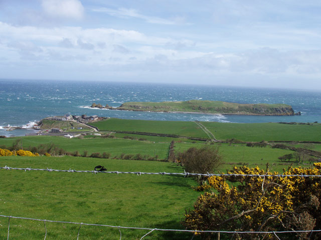
Sailing into Portmuck harbour from Scotland takes you past the small Isle of Muck - seen here with the north end of the Gobbins Cliffs in Islandmagee behind.

 The only landing place on the island is on the landward side, and it was here that smuggled horses from Scotland were landed out of sight of any patrolling customs and excise boats. On the Gobbins coast almost opposite is a cave known as 'horse cave' where the smuggled horses were also hidden. The inward horse trade was the counterbalance to the outgoing cattle boats destined for the great drove roads of Scotland.
Looking down on the island from the high ground in the middle of the peninsula, the small harbour of Portmuck can be seen to the left, hidden from the  isle by a small headland with farm buildings on top.
This scene has hardly changed in 100 years since the old photograph below was taken.

The ruins of Portmuck Castle are only the base walls of a stone tower built in the 1590s (see earlier posts "The Big Picture: Eslers and the 'Scotch' Cattle Drove Roads of mid Antrim", and "Dalways Bawn: The Earl of Essex's Plantation in east Antrim). It sits among and behind the farm buildings on the headland, so that it could overlook both the harbour and the 'sound' of water between the headland and Muck Isle. The large building down at the harbour was the Coastguards Building, which in the 1800s replaced the castle as the customs control center for the control of livestock imports and exports.

This was the end of the cattle trail as far as the old drove road from Ballynure, across the Commons of Carrickfergus and past Dalway's Bawn, but it was the beginning of the horse trail in the opposite direction, for Ballynure's horse fair was one of the biggest in the county. When I was a boy, the shore opposite Muck Isle could only be accessed by climbing over the limestone rocks at the headland (there is a footpath now).
 From this headland, where the castle ruins are, the shore is a limestone platform of white rocks which contrast completely with the black basalt rocks of the Gobbins cliffs. The castle wall rises straight from this headland on the Isle of Muck side, so that it had a clear view of the 'sound' and the causeway that linked the island. This natural causeway can be waded across at low tide, and of course, livestock could be driven across at this point too.

 There is a very interesting account of how (because of the smuggling trade) the locals were unwilling to admit, even to Scots 'plantation' landlords, that there were any horses 'to be had' in the district in the early 1600s. The source is a letter of 1631 from J. Montgomery of Newton (Lord Montgomery of the Ards in County Down) to Archibald Edmonston of Red Hall, Ballycarry. Of course there were plenty of horses about, but the fact that they were all busy working sounds like a typical Ulster-Scots bargaining tool to effect a sale at an extortionate price.
"J. Montgomerie to Archibald Edmonstone of Duntreath. Requesting the loan of some horses.
1631, April 21st, Knockfergus [Carrickfergus]. - 'Worshipfull and loving coosen, It hathe so falne out that in my passage from Dunstey I have been forced to land far doun in Iyeland McGhie [Portmuck, Islandmagee] so as I ame forced to employ my freinds for supplie of horses, and in regarde the countrey is upoun the heate of there labour, I must intreate yow for the laine of some three or four garreins [small work horses] for the transporting of myself and company to the Newtoun [Newtownards] ... Signed, Montgomerie
[Reply on same page] Right honourable my, I sent your Lordship thrie garreins and for this present I have non els exept my gray hors that rane ane cours yeisterday, and I dar nott ventur him so schoune efter the race. My Lord, I tak very unkindly that ye suld have gone by this cottage, always I hop your Lordship vill mak ane amends. Thus in quhat I am able I remain ... Signed, Ar. Edmonstoun. "
Of course, I should have repeated in this post that the names of Portmuck and of Muck Isle are both derived from the Irish Gaelic word for 'pig' (muc) and the names have nothing to do with the state of cleanliness of the place! But it also shows that the so-called 'cattle trail' was frequented by other livestock as well - particularly horses and swine.
 The Gobbins cliffs in Islandmagee run almost continuously between the sea-ports of Whitehead and Portmuck, so that these two tiny harbours were the only places the cattle trade from Dalway's Bawn to Scotland could operate from. This 100-year old romantic painting of the Gobbins does not capture the terror which these cliffs held for me as a young boy. There were sea caves that could only be explored by boat, and I remember being taken in a local fishing boat from Boneybefore - the only time I ever saw those caves up close.

In the 1960s we could still walk along parts of a cliff path from the Whitehead end, but the footbridges had collapsed before the stretch where the caves were.
The Gobbins path was built as a tourist attraction for visitors traveling from Belfast to Whitehead on the newly constructed railway in the late 1800s. It was a marvel of engineering with iron suspension bridges giving spectacular access.

 As a boy, we could actually 'tight-rope' walk across some of the remaining girders, until the whole path was closed off for safety reasons in 1961.But the real terror for me was when we would walk along the cliff tops. I had - and still have - a fear of heights, but the Boneybefore boys were intent on adding seagulls eggs to our collection. Egg-collecting is of course illegal and regarded as 'bad behaviour' now. But we thought it was only bad if you ignored the 'one-egg-only-per-nest' rule.

It was the other lads who went down the cliff, not me! But that wasn't because of any scruples I might have had about egg-collecting. The last time we tried it my friends got stuck half-way down, and called up above to me to go and get a rope from a farm. So off I went to the nearest farm across a few fields as fast as my trembling legs could take me. The two men in the farmyard just shrugged their shoulders as if a cow had got out of the field again, lifted two ropes hanging ready, and effected a rescue. Hardly a word was spoken, even back at the farmhouse where we were given a cup of tea. "Ye'll stick to the road in future then?" the older man said. "Ay", I said, and meant it.
 In this detail of a map prepared for Sir Thomas Smith's Plantation of the Ards in 1572, "Belfurst" (Belfast) is shown at the head of the "baye of Knokfergus" (Carrickfergus Bay, as Belfast Lough was once known). But just north of Knokfergus (west is at the top of this map), on the barely distinguishable peninsula of Islandmagee, is marked "Portmuk" (Portmuck).
 Postscript: I had just finished this post when Mark Thompson e-mailed me the short message: "Here's another"! This map is what was attached - it must be about the same date as the 1572 one as it has "Smites" castle marked on the Ards peninsula. But here again is "Karregfergus" and "Port Muk" (and perhaps Muck Isle marked as "The Kowe").


