Showing posts with label cattle drovers. Show all posts

Thursday, 6 January 2011

Cattle men from Scotland? The Eslers at Dalways Bawn

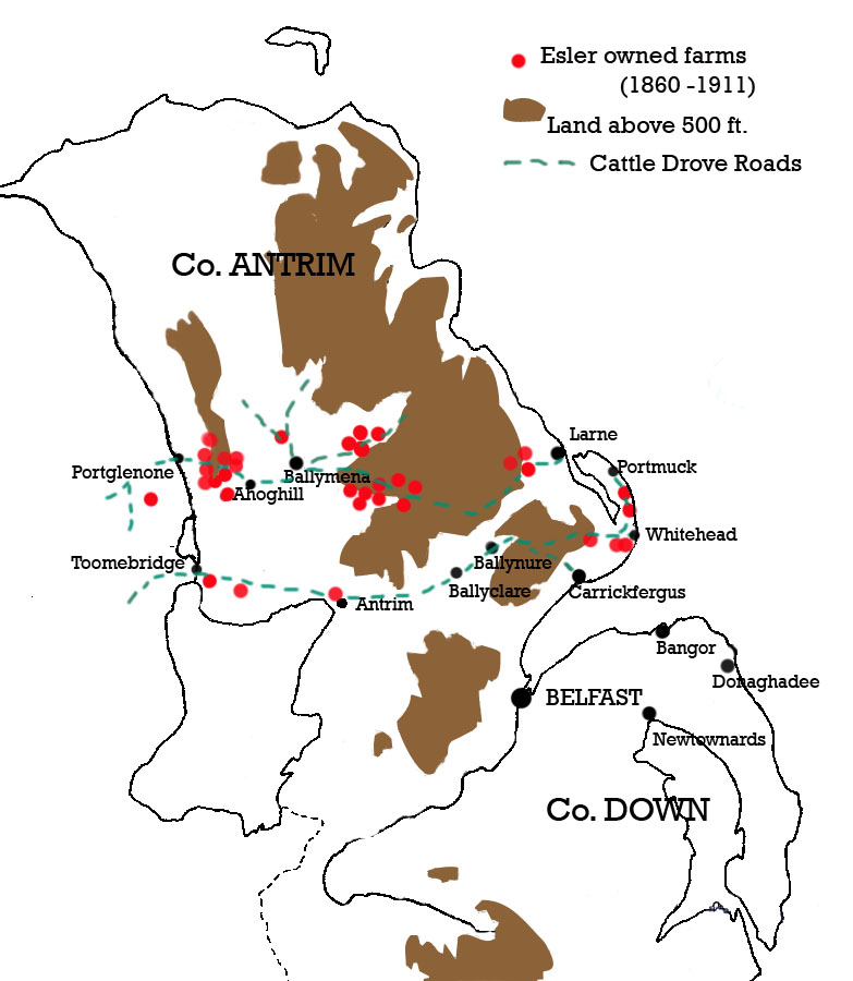
In 1860, two James Eslers (father and son) were living beside each other a few fields away from Dalways Bawn. James Esler, senior, was in the home-townland of the Dalways at Bellahill as a byresman. He held his small thatched cottage from one of Marriott Dalway's main tenants - Alexander Hart. James Esler, junior, was similarly stationed nearby, but as he was in the townland of Dobbsland, and a Dobbs' tenant, he may have been a cattle hand at Castle Dobbs.

These Eslers were part of an extended family group (all spelled
Essler in the 1860 Land Valuation) that were involved as cattle drovers, dealers and steaders at the Whitehead and Islandmagee end of the Commons cattle trail between Ballynure and Scotland. My earlier post "The Big Picture: Eslers and the 'Scotch' Cattle Drove Roads of mid Antrim", August, 2010, has the details of these Eslers and the more numerous group in mid Antrim that handled the Portglenone to Scotland cattle trail via Ahoghill and the port of Larne.

But where did these Eslers come from? They were all lowland Scots, arriving in east Antrim in the 17th century as horse and cattle drovers, and small hill farmers 'servicing' the cattle trails, according to family tradition. (My own great-grandfather was another James Esler from a hill-farm in Ballybeg, near Ahoghill).

In 1666 we get our first glimpse of the Antrim Eslers in the Hearth Money Rolls, prepared as a tax on all householders with a fixed chimney in their house. They then spelled their name
Assler, Asslar or Ashler, but appear to be absent from the small Parish of Kilroot, which includes the townlands of Dobbsland and Bellahill. In practice, the names on this list don't include the landless, labouring classes, only farmers and landowners, and so although we do have a Mr Richard Dobb, a Mrs Dalway, a Mr Alex Dallway and a David Hart (an ancestor of Alexander Hart in 1860, and a descendant of the Capt. Hart who first settled here with John Dalway in the reign of Elizabeth I) the absence of an Assler/Esler from the 1666 Hearth money roles is not significant. But in the adjacent Parish of Templecorran, we find a James Asslar in 1666. This Parish covers the land between Ballycarry, Dalway's Bawn and Whitehead (where the 100 acre farm of William and David Essler controlled the land behind the port of Whitehead in 1860). There were no other Asslers in east Antrim in 1666, not even in Islandmagee where the farms of Patrick and Andrew Essler were in 1860.

Apart from this 'Whitehead' James Asslar, there are only 4 other Eslers recorded in the Hearth Money rolls for 1666 for Antrim. Three of these were living near the port of Larne: In the Parish of Kilwaughter we have
John Ashler in Ballyhampton townland on the Agnew estate close to the port, and William Ashler on the nearby Agnew demesne. These names were both spelled 'Asler' on a repeat listing of 1669. A Thomas Ashler was living somewhere south of Larne, in either Inver or Glynn Parish in 1666. Family tradition has it that three Esler brothers came from Scotland in the 1600s and settled in three different parts of mid and east Antrim, giving rise to all the Antrim Eslers. If this is correct, then the main original settlement seems to have been at Kilwaughter near Larne, on the estate of the Agnews of Kilwaughter Castle and Lochnaw Castle near Stranraer in Scotland. The only other Esler in the 1666 Hearth Money Rolls is John Ashler at Rathkeen in the Parish of Rathcavan. This is on the upland between where the Braid and Glenwhirry river valleys run down to Ballymena, and where 'Eslertown' and the main concentration of Eslers survive along the Portglenone to Larne cattle trail.

So, if the '3 brothers' story is true, it seems that the first and main settlement of Eslers was at Larne, and the secondary settlements were at Rathkeen near Broughshane in mid-Antrim, and Whitehead/Ballycarry in east Antrim.

This gives us a real clue to the Scottish roots of our Eslers, for the Agnews of Kilwaughter Castle were from immediately across the North Channel at Lochnaw - between Portpatrick and Stranraer. And Portpatrick was the port of entry for the enormous cattle trade from Donaghadee in county Down, and the beginning of the major Galloway Cattle Drove road to Carlisle. In A.R.B. Haldane's book, "The Drove Roads of Scotland", he states that between 1786 and 1790, over 55,000 head of Irish cattle were imported into Portpatrick, and in 1812 as many as 20,000 were landed. His map of the drove roads of Scotland shows the sea link for this trade between Donaghadee in county Down and Portpatrick.


Here then is a short abstract about the Agnews of Lochnaw and Larne (Kilwaughter):


Lochnaw Castle
In 1375 "The Agnew", Lord of Larne, went to Ireland with Edward Bruce, younger brother of King Robert the Bruce where he had been invited by the Irish Lords to help rid them of the English and rule in their place. Agnew stayed with Edward in Ulster for three years while he attempted to establish his power.

Andrew Agnew of Lochnaw was granted the lands and constableship of Lochnaw Castle in 1426. In 1451 he was appointed Sheriff of Wigtown, an honour still held by direct descendants today.
During the 15th century the Clan Agnew rose to power however this was under the powerful Clan Douglas. When the Douglases fell from the Kings favour the Agnews in Galloway in fact benefited. However this then brought them into many conflicts with the Clan MacKie and the Clan MacLellan.
16th century
In the 16th century during the Anglo-Scottish Wars Andrew Agnew of Lochnaw, was killed at the Battle of Pinkie in 1547 in fighting against the English.

Sir Patrick was MP for Wigtownshire from 1628 to 1633, and again from 1643 to 1647. He was created a Baronet of Nova Scotia on 28 July 1629. He died in 1661 and was succeeded by his eldest son, Andrew, who had been knighted in his father’s lifetime and who was also returned as MP for Wigtownshire. He was created Sheriff of Kirkcudbright as well as Wigtown in the 1650s, when Scotland was part of the Protectorate with England. He married Anne Stewart, daughter of the first Earl of Galloway.
The fifth Baronet, another Andrew, married a kinswoman, Eleanor Agnew of Lochryan, the union producing no fewer than twenty one children.

So the Agnews were known as "Lords of Larne" from the 14th century when they first visited east Antrim with Edward the Bruce! Their Kilwaughter estate was granted in the 17th century as part of the Ulster Plantation of lowland Scots, and by 1659 Kilwaughter Parish had the highest proportion of "Scotch" inhabitants of any Parish in Ireland (over 90%). It may well be that the first Eslers came with the Agnews from their Lochnaw estate near Portpatrick - or maybe they were continually moving west, "sourcing" cattle back along the drove routes from Dumfries and pioneering the western extension of this deep into county Antrim. This is well worth somebody chasing up on the ground in Scotland! But certainly our Eslers at Dalway's Bawn were part of something bigger as far as the cattle trade with Scotland is concerned. One thing is sure - the Esler story is the classic Ulster-Scot story.

Monday, 9 August 2010

The Big Picture: Eslers and the 'Scotch' Cattle Drove Roads of mid Antrim

The old cattle drove routes across county Antrim run east-west (across the grain to the north-south direction of most of the main lines of communication). This is because they were heading to the main ports (especially Larne) connecting them to the Scottish drove roads that have been so well documented already on the other side of the 'sheuch'. One Scottish drove road in south-west Scotland is described as 'starting in Portpatrick' where 20,000 cattle a year were being landed from Donaghadee in county Down in 1800. (The parallel story of the county Down drove roads is one I'll leave for another day!)

For Ulster-Scots, these routes were the main arterial connection between the Scottish mainland and the Ulster-Scots settlers of the 17th century and later. This on-going connection is what shaped the very core of the Ulster-Scots heartland in terms of language, culture and religion. Along these routes are the broadest Ulster-Scots speaking areas, and the most dominantly Presbyterian communities in Ireland.

But my efforts at retracing the main drove road from Portglenone to Larne came about as a spin-off from researching the family history of my mother's grandfather - James Esler - whose family came from the cluster of small Esler hill-farms on the 'Long Mountain' between Portglenone and Ahoghill in the 1860s.

Esler is a lowland Scots name (originally German, I understand, meaning 'donkey dealer', or 'hosteler'), and 95% of all Eslers in Ireland were living in County Antrim in the early 19th century. Family tradition has it that three brothers came over from Scotland in the 1600s and settled in three areas - Kilwaughter (on the mountain slopes behind Larne), Eslertown (at the Cross between the Glenwhirry and Braid valleys, east of Ballymena), and Ballynafie (between Portglenone and Ahoghill on the Long Mountain). The map shows these three clusters, and it seems the Eslers' control of the hill pastures was strategically placed at points on upland pasture between market towns where the drovers and their beasts could stop off for the night.

So, that's where I was with my 'historical exploration' when I discovered that two James Eslers (father and son) were also living in 1860 beside Dalway's Bawn, east of Eden in Carrickfergus.

Two things seemed to confirm that this was connected to a cattle trail from Ballynure to Whitehead and Islandmagee. In the first place, both James Esler and his son from Bellahill were 'Agricultural labourers' rather than full farmers, and James Esler Senior was a 'byresman' for Dalway's Bawn itself! (A 'byre' is a cattleshed). Secondly, there were other Esler farms in the immediate vicinity. A 90-acre farm right on the coast at Whitehead was shared in ownership between two Esler brothers in 1860. These brothers were also joint landlords for the newly-erected Coastguard Station and houses in Whitehead. What an opportunity to keep an eye on the Customs and Excise men! Yet another two Esler farms were located in the townland of Balloo, in Islandmagee. These were on the Gobbins Road from Whitehead to Portmuck, which had a small harbour where pigs were exported to Scotland and horses brought in. The Gobbins cliffs between Whitehead and Portmuck had a few hidden coves and 'smugglers caves' - and one of these was on the Esler farm at Balloo! A 'horse cave' at Portmuck was where horses smuggled in were supposed to have been hidden, and I like to think that the Eslers were not only bringing cattle and pigs from Ballynure to send to Scotland, but were bringing horses in the other direction - to Ballynure Fair Hill which was renowned for its annual horse fair.

Going back to the Elizabethan history of this part of the world, Portmuck Castle and Castle Chichester at Whitehead were important outposts of Chichester at Carrickfergus, but they were also linked in terms of strategic defense to Dalway's Bawn.

Castle Chichester was excluded from the Esler farm land which surrounded it at Whitehead, as it was owned by the Chichester family, but the adjacent port was where regular postal packages from Scotland were landed in the 18th century. Of course, as I observed before, 'muc' in Irish is 'pig' - so 'Portmuck' means 'swine port' (nothing to do with the cleanliness of the harbour!)

Saturday, 10 July 2010

The Rise of John Dalway's Cattle 'Empire' in East Antrim

Take these ingredients:

1. Dalway's Bawn;
2. The
Cattle Trail across the Commons from Ballynure to the coastal ports linked to Scotland;
3. Dalway Manor - the large tracts of land acquired in east Antrim by Dalway (and his tenants and partners).

Put them together and what comes out of the mix? They reveal the big picture of a cattle trading 'empire' that began in the 1500s and was still going strong in 1850.

The map of these combined ingredients is worth a close look (click on it to see it properly), for it tells the whole story:
Note the lands to the north west around Ballynure and its Fair Hill which was the Ballynure part of 'Dalway Manor';
Note the lands to the east around Dalway's Bawn that made up the other half of Dalway Manor;
Note the 'Aldermans' land in the North-East Division of the County of Carrickfergus that was controlled by Dalway and his tenant-farmers (and which gave his bigger operation the right of access to the Commons and grazing rights across it).
When the Cattle trail is shown linking all these, the pattern suddenly leaps out in a way that no written history has yet recorded, and the true purpose of Dalway's Bawn is revealed.

The earliest known date of a grant of the Broadisland and Kilroot lands to John Dalway was in 1591 from his wife's cousin, Shane McBryan O'Neill. But when Shane as chief of north Clandeboy died in 1596, the country was in turmoil. The MacDonnells had overrun the district by 1597, and after the death of Sir John Chichester at Battle of Pin Well (on Dalway's lands at Ballcarry), John Dalway, John Dobbs, Lieutenant Hart and Sir Moses Hill - all with an interest in these lands, had to flee and wait for quieter times.

The end of the Elizabethan war in Ireland was marked by the surrender of Hugh O'Neill on the very eve of Elizabeth's death in 1603. The new monarch was James I of England and Scotland, who had formerly been James VI of Scotland and a kinsman of the Scottish MacDonnells of the Glens. But John Dalway did get a re-grant of 'such lands as he held in right of his contract with Shane O'Neill'.

A few years later, in 1608, came the definitive 're-grant' of these lands to John Dalway from James I, 'with the consent of the commissioners' for the Ulster Plantation. It was probably the plantation commissioners that introduced what was for them a standard clause requiring Dalway to build:
'within the next seven years, a castle or house of stone or brick ... with a strong court or bawne about the same, in any convenient place, within the territory of Ballinowre'.
The lands of this grant are described in great detail, not only listing the individual townlands of the two separated territories of Ballynure and Broadisland, but also giving a precise description of the boundaries of these two estates (see the above map for the general locations).

There are a few more interesting details in the 1608 grant to John Dalway. He was
'to hold at Thomastowne, within the cinament of Ballynowre, a friday market, and a fair on the feast of St Bartholomew, and two days after; unless the fair-day fall on a Saturday or the Lord's day'.

Another part of the grant confirmed Dalway's holdings as a freeman within the County of Carrickfergus as:
'the half burgage ... on the E. side of High street, in the town of Carrickfergus ...
two parcels of ground near the E. end of said town ... one extending to the commons of the said town, northwards ...
lately assigned to said John Dalway for his Aldermans share of said townlands of Carrickfergus.'
The grant then goes on to mention that Dalway could in turn grant any part of the estate, apart from 600 acres for his own demesne, to any English or (lowland) Scottish subjects without needing 'the king's license' to do so. Some breakup of the estate did occur, but nothing that interfered with the basic economic thrust of the cattle trail. A Scottish noble man, Sir Archibald Edmonston, took a large section of the estate at Red Hall around Ballycarry in 1609, but this only served as a catlyst for thousands of lowland Scots settlers to overwhelm the district and secure the northern approaches that had been so vulnerable to incursions from the Glens. John Dobbs of Castle Dobbs married Margaret Dalway, the daughter of John Dalway and Jane McBryan O'Neill, and so the Dobbs family eventually owned much of the Kilroot and Ballynure lands.

When these lands are mapped, the whole thing suddenly makes sense. But it is also clear that the Dalway control of this cattle trail from the Sixmilewater Valley through to the ports for Scotland at Whitehead and Islandmagee could not have happened without the important central link in the chain - the Commons of Carrickfergus.

It was the old cattle drove trail across the Commons of Carrickfergus that connected Dalway's Ballynure and Broadisland estates. The townland of Castletown just east of Ballynure not only includes the site of the 'old castle' and bawn at the river crossing of the Castle Water, but also the 'Ballynure Fair Hill' which held fairs for cattle and pigs in May, September and October, with a large horse fair also held on nearby Reagh Hill in May, November and Christmas Day. Many of the pigs and cattle sold at Ballynure Fair ended up on boats leaving Portmuck (
muc is Irish Gaelic for 'pig') or Whitehead for the drove roads in south-west Scotland. Dalway's Bawn was their last stopping place before the 'end of the trail'.

Saturday, 3 July 2010

Dalway's Bawn: The Early Scotch Dimension

(This is the fifth of a series exploring the history of the Dalway cattle drove trail)

Although the Earl of Essex had died in 1576, the remains of his Elizabethan English colony settled in the town of Carrickfergus.

John Dalway was one of those who came to the fore in the town by the 1590s, along with John Dobbs and a Lieutenant Harte, and these three men were to play a critical role in the story of Dalway's Bawn and the later cattle trail.

By the late 1600s, Carrickfergus had entrenched its 'English only' policy within the walls of the town, so the suburbs shown to the west remain to this day as 'Irish Quarter' (where the town's Catholic Church is located). 'English' meant 'Established Church', and the town's freemen were required all to attend the old Anglo-Norman church of St Nicholas in the town. The suburb to the east (also shown in the foreground of the inset illustation) is 'Scotch Quarter' along a road leading east - to Boneybefore and Kilroot.

The 'big' church all of us in Boneybefore used to attend for special occasions was Joymount Presbyterian Church in Scotch Quarter. The name 'Joymount' comes from the large mansion shown in the inset. Joymount House (called after Lord Mountjoy, the Lord Deputy in Dublin) was built in 1610 by Sir Arthur Chichester, Governor of Carrickfergus and Ulster, and brother of Sir John Chichester who had been Governor of Carrickfergus until he was killed by the Antrim (Highland) Scots at Ballycarry in 1597, with Dalway, Dobbs and Harte fleeing the scene. But the 'Scotch' of the Scotch Quarter - and most of east Antrim and Islandmagee - were not 'Highland Scots', but were lowland Scots that had settled after 1603 when James VI of Scotland took over from Elizabeth I as James I of England and Scotland.

The early 'Scotchmen' that were threatening Carrickfergus in the 1590s were Highland, Catholic and Gaelic-speaking Scots in the glens of north-east Antrim known as the 'MacDonnells of the Glens'. Their main stronghold was Dunluce Castle at the far end of County Antrim, and the seeds of conflict had already been sown by Essex with his raid on Rathlin Island in 1574.

In 1594, twenty years after John Dalway first settled in Carrickfergus, he was still living there in a tower-house with his wife Jane McBryan O'Neill (a close relative of Shane McBryan) and their daughter Margaret (who later married John Dobbs of Castle Dobbs). By this time John Dalway had been appointed 'Sheriff of Antrim' and was writing regular intelligence reports to the Lord Deputy in Dublin and Sir Henry Bagenal in Newry. The theme of these letters was always the same - the loyalty of the Clandeboy O'Neill's (particularly Shane McBryan O'Neill, his wife's cousin) was solid, but they were under intolerable pressure from Hugh O'Neill, Earl of Tyrone, and James McSorley Boy MacDonnell of the Route (north Antrim).

John Dalway had got a grant from Shane McBryan O'Neill of the lands at Broadisland (Ballycarry) and Kilroot in 1591, paying in cattle rather than money yearly to Shane and his heirs. In 1594, as Sheriff of Antrim, John Dalway 'examined' Shane McBryan and wrote to the Lord Deputy that

"the Earl of Tyrone sent O'Hagan to Belfast to have the said Shane become his man and run against the Queen."
But Shane had resisted and provided Dalway with 'promises and slanty'.

A year earlier, in 1593, Dalway had reported from the 'Camp at Comber' that

"Owen McHugh, that killed Neal McBryan Ferta's son, has drawn a large force to assail the great Ardes."
A 'great prey' of cattle had been taken fron Neale McBryan O'Neill of north Clandeboy, and 500 men were beseiging him.

As 1594 progressed, Dalway's reports concentrated more and more on the threat posed by the Antrim Scots.

"James Oge McSorley Boy MacDonnell took from Neale McBryan Ferta the number of 200 cows besides garrans (horses) and other spoil, and doth threaten to make his repair thither again."
He urged the Lord Deputy to send some men to help defend Shanes Castle at Antrim, for "if it should be lost the whole country will be thrown open". In July 1594 Ensign John Dalway wrote again to the Lord Deputy that the cattle belonging to the townsmen of Carrickfergus had been taken prey by James MacSorley Boy MacDonnell. He feared that "the town will be overthrown if more force is not speedily sent." In October the same year he reported that £300 worth of lead and powder had been landed in the Glens of Antrim from Scotland.

The reinforcements that arrived in Carrickfergus in 1595 were under John Chichester from Devon who was Sergeant-Major of the Elizabethan army in Ireland. As Shane McBryan had apparently joined the Earl of Tyrone in rebellion, Chichester captured Shanes 'bawn' at Antrim, and took Shane to Carrickfergus Castle where he again pledged support for the Queen. However, Shane died while still at Carrickfergus and his estates were forfeited to the Crown. Dalway later received a re-grant from the Crown of the east Antrim estates that he had previously been renting from Shane. Sir John Chichester was then appointed Governor of Carrickfergus and John Dalway made 'Deputy Victualler in Ireland'.

But the threat of the Antrim Scots came to a dramatic head on Dalway's lands at the 'Battle of Pin Well' in Aldfracken Glen (near Ballycarry) in 1597 .

James McSorley Boy MacDonnell had brought a large force down from the north of the county into east Antrim. Having plundered Islandmagee he concealed the most of his men in Aldfracken Glen near Ballycarry, and approached the North Gate of Carrickfergus Town in a provocative show of defiance. Sir John Chichester took the bait, and pursued him with about 20 of his horsemen, including John Dalway, John Dobbs and a Lieutenant Harte who later provided an eye-witness account.

When Chichester and his men reached Aldfracken Glen, they were set upon by the larger force of Antrim Scots, and a complete rout occurred. Sir John Chichester was captured, and MacDonnell cut his head off on a nearby rock, tossing it to his men to play football with. About ten of Chichester's men were also killed, but several others escaped by swimming across Larne Lough and hiding in the caves near the Gobbins in Islandmagee. Although he was injured, Lieutenant Harte escaped to Islandmagee as well, "and so by swimming over saved my lief." Among the other runners was Lieutenant Dobbs who "retreated under a bridge until the danger had passed." Another runaway was Lieutenant John Dalway, who concealed himself for a time in the dry flow or ooze left by the shallow water that had once separated Islandmagee from the mainland.

Sir John Chichester was replaced as Governor of Carrickfergus by his brother, Sir Arthur Chichester. It was Sir Arthur who built the mansion house of Joymount in the town in 1610, and who had led the Elizabethan forces across into Tyrone to finally put down the rebellion of the Earl of Tyrone in 1603.

In St Nicholas's Church in Carrickfergus, in a side-aisle reserved for the Chichesters, is a monument to Sir Arthur and his wife. Beneath them is an effigy of Sir John. When James MacSorley Boy MacDonnell as an old man visited the monument, he is reported to have pointed to the effigy of Sir John and said,

"How the deil did he come to get his head back, for anes I taen it frae him".
Underneath the Chichester Aisle in St Nicholas Church is the Chichester's family burial vault with lead coffins of various early Chichesters. The skull of Sir John sits on a stone shelf at the back.

Once the Elizabethan war in Ulster was ended in 1603, three of the men lucky to escape with their lives at Ballycarry, (John Dalway, John Dobbs and Lieutenant Harte), were soon to play a central role in the next stage of the story of Dalway's Bawn and the cattle trail it controlled.


-->


Tuesday, 1 June 2010

Dalway's Bawn and the Marshallstown cowboys


(This is the 1st of a series exploring the history of the Dalway cattle drove trail)


To find Dalways Bawn as I did as a boy, you would have to be wearing a Davy Crockett hat and be exploring the Copeland Water upstream in an attempt to find its source. The Copeland Water marks the eastern boundary of Eden village and the old medieval county of Carrickfergus. If you traced the river from Eden down towards the sea, it would take you to Swift's cottage after about 1/2 mile. But upstream, after more than a mile, another world is reached where Marshallstown, Dalways Bawn and Castle Dobbs together once defended the eastern approaches and cattle drove roads to and from Carrickfergus. If you want to reach the Bawn by road, take the main Larne Road from Carrickfergus, through Eden village and about 1/4 mile after you cross the Copeland Water, take a left turn up a road called 'Tongue Loanen'. This will take you straight past the front of Dalway's Bawn on the back road to Ballycarry.

When we first saw Dalways Bawn, we thought it looked like a wild west stockade, the sort we had seen Davy Crockett defend at the Alamo in Carrick picture-house, only this one was made of stone instead of timber. Well we weren't too far off the mark, for the scores of bawns built in the early 1600s during the Ulster Plantation were exactly that - cattle forts where the settlers could bring their cattle into when under attack from the native Irish (cattle-raids being the order of the day back then). The word 'bawn' is a corruption of the Irish bo-dun or 'cow-fort', and they were usually built with 4 corner towers as defensive 'flankers' and a dwelling house for the plantation landlord in the middle.

Dalway's Bawn was built in 1608 by John Dalway, although he had actually settled here some 30 years earlier. He first arrived in Ulster in 1573 along with Walter Devereaux, Earl of Essex, when Elizabeth's reputed 'favorite' attempted an early plantation in east Antrim. John Dalway married Jane MacBryan O'Neill a sister of the former local dynastic chief Shane MacBryan O'Neill. Their daughter Margaret Dalway then married John Dobbs, who had also come over with an Elizabethan English army in the 1590s and built the tower-house at Castle Dobbs just a few hundred yards away facing Dalways Bawn.

Both Dalways Bawn and Castle Dobbs were in Kilroot Parish - just east of the Copeland Water and the medieval County of Carrickfergus - for a very good reason. The land to the west of the river was not available for plantation as it had been in Anglo-Norman English hands since the 13th century! The 'Carrick' side of the Copeland Water at this point was - and is - known as 'Marshallstown'. In the 1600s it was held by Sir Baptist Jones, who is better known for his work as a Plantation land agent for the London Companies in Londonderry. His lease for Marshallstown showed that he also claimed a few hundred acres 'across the mearing' in Kilroot Parish. Today this is the tiny townland of 'Crossmary' between Dalways Bawn and Marshallstown.

Again, with our Davy Crockett hats on, we assumed that Marshallstown was where the 'Marshal' held out - after all Carrick had a Sheriff! Only in later years did I learn there was some truth in that too. In the 12th century an Anglo-Norman lord living in Carrickfergus was made 'Marshal' of the Earldom of Ulster. His name was Sir Roger de Copeland, and lands were set aside at the eastern end of the county by the town corporation for the support of his office. Not only was this the origin of Marshallstown, but he gave the Copeland Water its name too.

But the office of Marshall was no sinecure. The duties included securing the eastern boundaries, and controlling the cattle trade across it. Both these duties shifted to Dalways Bawn and Castle Dobbs in the 1600s when lowland Scots settlers poured into east Antrim.

And that is where the story comes down to my own family connections. My mother's family were 'Eslers' who had come over from Scotland in the 1600s as cattle and horse dealers, hill-farmers and cattle-drove 'facilitators'. It still is a fairly unusual name here and even by the 1860s, 90% of all the Eslers in Ireland lived in mid and east Antrim - on hill farms along the cattle drove routes to the port of Larne. Although I was born in Larne, our family moved near to Carrick when I was 2 years old. Recently I found a new 'branch' of these Eslers in Islandmagee, feeding the local cattle trade to Scotland from Portmuck. And then, to my amazement, I discovered a John Esler in 1860 as a tenant on a farm beside Dalways Bawn. Little did I think I was playing cowboys on the very lands where my mother's family had been acting out the real thing.

The farm on which John Esler lived at Dalways bawn belonged to an Alexander Hart, who then had lands in Crossmary and his main 'home farm' in 1860 was beside where I lived in Boneybefore. Victor and Ian Hart were at Eden Primary School with me, and I knew every field and hedge on their farm up 'Hart's Loanen'. But as that farm was not East of Eden, I'll leave that story for another day.

A postscript about the Davy Crockett hats. At Eden Primary school I sat beside Eric Glynn, who also lived beside me in Boneybefore. Eric had a kindly grannie known to us all as 'Grannie Hamilton'. Like all the old widows in those days she wore black from head to toe. But one of the kindliest acts I remember was in Eric's house playing an old 78 record with 'Davy Crockett' on one side and 'Robin Hood' on the other. Grannie Hamilton came into the room with a fox stole she had. She cut it in two and made two Davy Crockett hats for us. Eric of course got the one with the real fox's tail at the back, and I had only a fox leg with claw still attached on mine. All the same we really felt we had one up on the rest of the gang with their artificial shop-bought ones.